Rentschler Field (stadion) Hotellit
Suositeltavat hotellit lähellä maamerkkiä: Rentschler Field (stadion)
Lisää hotelleja lähellä kohdetta: Rentschler Field (stadion)-
 333 Roberts Street, East Hartford, Connecticut 06108, US Näytä kartta
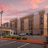
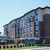
Comfort Inn & Suites East Hartford - Hartford
Comfort Inn & Suites East Hartford - Hartford sijaitsee keskustassa, ja Connecticutin kokouskeskus sijaitsee 5 minuutin ajomatkan päässä ja Xfinity Theatre... Lue Lisää
7.6/10Hyvä1006 arvioon1.3 kmIlmainen Wi-FiValitseAlkaen USD 169per huone / yötä kohti -
 363 Roberts Street, East Hartford, Connecticut 06108, US Näytä kartta
Fairfield By Marriott Inn & Suites East Hartford
Connecticutin kokouskeskus sijaitsee 5 minuutin ajomatkan päässä ja Xfinity Theatre sijaitsee 7 minuutin ajomatkan päässä majoituspaikasta. Tämä hotelli... Lue Lisää
10/10Loistava1 arvioon1.3 kmIlmainen Wi-FiValitseAlkaen USD 231per huone / yötä kohti -
 363 Roberts street, East Hartford, Connecticut 06108, US Näytä kartta
Towneplace Suites By Marriott East Hartford
Connecticutin kokouskeskus sijaitsee 5 minuutin ajomatkan päässä ja Xfinity Theatre sijaitsee 7 minuutin ajomatkan päässä majoituspaikasta. Tämä hotelli... Lue Lisää
1.3 kmIlmainen Wi-FiLisätietoja tästä hotellista:Valitse -
 490 Main Street, East Hartford, Connecticut 06108, US Näytä kartta
Economy Inn
Connecticutin kokouskeskus ja East Hartford Shopping Center sijaitsevat 5 minuutin ajomatkan päässä majoituspaikasta. Tämä perheystävällinen hotelli... Lue Lisää
6.2/10Fair701 arvioon2.1 kmIlmainen Wi-FiValitseAlkaen USD 110per huone / yötä kohti -
 65 Glastonbury Blvd, Glastonbury, Connecticut 06033, US Näytä kartta
Homewood Suites by Hilton-Hartford South-Glastonbury, CT
Connecticutin kokouskeskus ja Bushnell Park (puisto) sijaitsevat 10 minuutin ajomatkan päässä majoituspaikasta. Tämä hotelli sijaitsee 6,1 km:n päässä... Lue Lisää
8.8/10Hyvä1004 arvioon3.7 kmIlmainen Wi-FiValitseAlkaen USD 280per huone / yötä kohti -
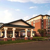
 351 Pitkin Steet, East Hartford, Connecticut 06108, US Näytä kartta
Hampton Inn & Suites Hartford/East Hartford
Hampton Inn & Suites Hartford/East Hartford sijaitsee keskustassa, ja Connecticutin kokouskeskus ja Xfinity Theatre 5 minuutin ajomatkan päässä. Tämä... Lue Lisää
8.8/10Hyvä1163 arvioon3.8 kmIlmainen Wi-FiValitseAlkaen USD 223per huone / yötä kohti -
 85 Glastonbury Blvd, Glastonbury, Connecticut 06033, US Näytä kartta
Hilton Garden Inn Hartford South/Glastonbury
Hilton Garden Inn Hartford South/Glastonbury sijaitsee esikaupunkialueella, ja Connecticut Science Center ja Connecticutin kokouskeskus sijaitsevat 10... Lue Lisää
8.6/10Hyvä1007 arvioon3.8 kmIlmainen Wi-FiValitseAlkaen USD 254per huone / yötä kohti -
 185 Brainard Rd, Hartford, Connecticut 06114, US Näytä kartta
Best Western Hartford Hotel & Suites
Best Western Hartford Hotel & Suites sijaitsee keskustassa, ja Connecticutin kokouskeskus sijaitsee 3 minuutin ajomatkan päässä ja Xfinity Theatre 7... Lue Lisää
7.8/10Hyvä1079 arvioon4.3 kmIlmainen Wi-FiValitseAlkaen USD 145per huone / yötä kohti