McKinney Falls State Park (luonnonpuisto) Hotellit
Suositeltavat hotellit lähellä maamerkkiä: McKinney Falls State Park (luonnonpuisto)
Lisää hotelleja lähellä kohdetta: McKinney Falls State Park (luonnonpuisto)-
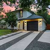
 4606 E Village Ct, Austin, Texas 78744, US Näytä kartta
Bedroom in Home 7 Miles from Downtown
South Congress Avenue ja Austinin kokouskeskus sijaitsevat 10 minuutin ajomatkan päässä. Tämä hostelli sijaitsee 11,8 km:n päässä kohteesta University of... Lue Lisää
2.3 kmIlmainen Wi-FiLisätietoja tästä hotellista:Valitse -
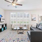
 Altidore Drive, Austin, Texas 78744, US Näytä kartta
Cozy 4BR House Close to Cota DT w Fast Wifi
University of Texas at Austin ja South Congress Avenue sijaitsevat 15 minuutin ajomatkan päässä majoituspaikasta. Tämä loma-asunto sijaitsee 15,4 km:n... Lue Lisää
2.2 kmIlmainen Wi-FiLisätietoja tästä hotellista:Valitse -
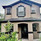
 5508 Apple Orchard Ln, Austin, Texas 78744, US Näytä kartta
Tulum Stay at Austin by The Key Rentals
South Congress Avenue ja Lady Bird Lake sijaitsevat 10 minuutin ajomatkan päässä. Tämä loma-asunto sijaitsee 11,6 km:n päässä kohteesta University of... Lue Lisää
1.9 kmIlmainen Wi-FiValitseAlkaen USD 738per huone / yötä kohti -
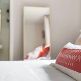
 6729 Broad Brook Dr, Austin, Texas 78747, US Näytä kartta
Solace in South Austin - Game Room
South Congress Avenue ja Austinin kokouskeskus sijaitsevat 15 minuutin ajomatkan päässä majoituspaikasta. Tämä loma-asunto sijaitsee 16,8 km:n päässä... Lue Lisää
3.2 kmIlmainen Wi-FiValitseAlkaen USD 464per huone / yötä kohti -
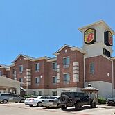
 3120 Montopolis Dr SW HWY 71 and Montopolis Dr, Austin, Texas 78744, US Näytä kartta
Super 8 by Wyndham Austin/Airport South
University of Texas at Austin ja Lady Bird Lake sijaitsevat 10 minuutin ajomatkan päässä. Tämä hotelli sijaitsee 9 km:n päässä kohteesta Sixth Street ja 6... Lue Lisää
3.7/5Hyvä965 arvioon3.4 kmIlmainen Wi-FiValitseAlkaen USD 103per huone / yötä kohti -
 8012 Chrysler Bend, Austin, Texas 78744, US Näytä kartta
Cozy Apartment in Austin by The Key Rentals
Circuit Of the Americas ja South Congress Avenue sijaitsevat 15 minuutin ajomatkan päässä majoituspaikasta. Tämä huoneisto sijaitsee 19,4 km:n päässä... Lue Lisää
3.5 kmIlmainen Wi-FiValitseAlkaen USD 146per huone / yötä kohti -
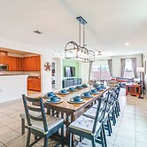
 7501 Lauper Dr, Austin, Texas 78744, US Näytä kartta
Luxury 2S Condo Hot Tub Gym Pool Airport
Lomakoti sijaitsee bisnesalueella, ja 15 minuutin ajomatkan päässä sijaitsee Circuit Of the Americas ja South Congress Avenue. Tämä loma-asunto sijaitsee... Lue Lisää
3.6 kmIlmainen Wi-FiLisätietoja tästä hotellista:Valitse -
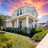
 8517 Capitol View Dr, Austin, Texas 78747, US Näytä kartta
10 Mi to Dtwn Austin: Family Home w/ Communal Pool
South Congress Avenue ja Austinin kokouskeskus sijaitsevat 15 minuutin ajomatkan päässä majoituspaikasta. Tämä perheystävällinen mökki sijaitsee 17,8... Lue Lisää
3.7 kmIlmainen Wi-FiValitseAlkaen USD 549per huone / yötä kohti