Gants Hill Hotels
Popular Hotels near Gants Hill
More hotels near Gants Hill-
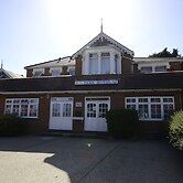
 327 Cranbrook Road, Ilford, IG1 4UE, GB Show map
Park Hotel
With a stay at Park Hotel in Ilford (Cranbrook), you'll be within a 15-minute drive of ExCeL Exhibition Centre and Thames River. This hotel is 9.5 mi... Read more…
6.4/10Fair989 reviews1.0 kmFree WifiSelectFrom USD 62per room / per night -
 27-37 Perth Road, Valentine Hotel, Ilford, IG2 6FT, GB Show map
For Students Only The Valentine in London
With a stay at For Students Only The Valentine in London, you'll be centrally located in Ilford, within a 15-minute drive of Thames River and Westfield... Read more…
0.2 kmFree WifiSelectFrom USD 124per room / per night -
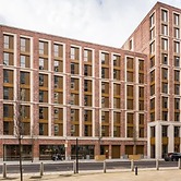
 17 Perth Road, Ilford, IG2 6BX, GB Show map
1 Bed-sleeps 4-free Parking-30 Min to Central Ldn
With a stay at this apartment in Ilford (Gants Hill), you'll be within a 15-minute drive of Thames River and Westfield Stratford City. This apartment is... Read more…
0.2 kmFree WifiFor more info about this hotel:Select -
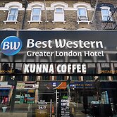
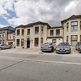
 60 Cranbrook Road, Ilford, IG1 4NH, GB Show map
Best Western Greater London Hotel
With a stay at Best Western Greater London Hotel, you'll be centrally located in Ilford, within a 10-minute drive of ExCeL Exhibition Centre and Thames... Read more…
7.2/10Good221 reviews1.7 kmFree WifiSelectFrom USD 155per room / per night -
 713 Eastern Avenue, Ilford, IG2 7RH, GB Show map
Premier Inn London Ilford - Newbury Park
With a stay at Premier Inn London Ilford - Newbury Park in Ilford (Newbury Park), you'll be within a 15-minute drive of Westfield Stratford City and ABBA... Read more…
8/10Good582 reviews1.4 kmFree WifiSelectFrom USD 55per room / per night -
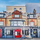
 16 Ilford Hill, Ilford, IG1 2DA, GB Show map
Belvilla Ilford Hill Hotel London
With a stay at Belvilla Ilford Hill Hotel London in Ilford (Loxford), you'll be within a 10-minute drive of ExCeL Exhibition Centre and Thames River. This... Read more…
7/1086 reviews2.2 kmFree WifiSelectFrom USD 104per room / per night -
 3-5 Argyle Road, Ilford, IG1 3BH, GB Show map
Best Western London Ilford Hotel
With a stay at Best Western London Ilford Hotel in Ilford (Valentines), you'll be within a 10-minute drive of ExCeL Exhibition Centre and Thames River. ... Read more…
7/10873 reviews1.8 kmFree WifiSelectFrom USD 78per room / per night -
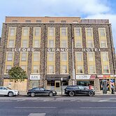
 130 Cranbrook Rd, Ilford, IG1 4LZ, GB Show map
Ilford Grand Hotel
With a stay at Ilford Grand Hotel in Ilford (Valentines), you'll be within a 10-minute drive of ExCeL Exhibition Centre and Thames River. This hotel is... Read more…
1.6 kmFree WifiSelectFrom USD 95per room / per night